


La Romieu Larressingle

norihtom
User
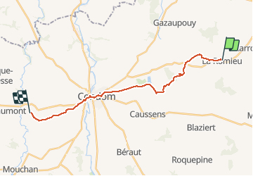

Length
20 km

Max alt
216 m

Uphill gradient
398 m
Km-Effort
26 km

Min alt
72 m

Downhill gradient
445 m
Boucle
No
Creation date :
2017-05-14 00:00:00.0
Updated on :
2017-05-14 00:00:00.0
5h30
Difficulty : Unknown

FREE GPS app for hiking
 SityTrail
IGN / Geographical institutes
SityTrail Plus
The world is yours!
About
Trail Walking of 20 km to be discovered at Occitania, Gers, La Romieu. This trail is proposed by norihtom.
Positioning
Country:
France
Region :
Occitania
Department/Province :
Gers
Municipality :
La Romieu
Location:
Unknown
Start:(Dec)
Start:(UTM)
299306 ; 4872923 (31T) N.
Comments